MWRA proposal at Fernald
With ballot access secured last week, I decided this week to focus a bit more on developing my campaign strategy and educating myself about the plans and proposals at the city-owned Fernald property. At the bottom of this blog post, I’ve shared a list of general resources about the Fernald property for those that are interested in doing their own research. However, first, I wanted to share some insights about what I’ve learned about the Massachusetts Water Resources Authority (MWRA) proposal to extend a tunnel into Waltham.
Other than the general information on the resources below, I’ve visited the proposed site in person, and I’ve reviewed the MWRA’s Final Environmental Impact Report report issued in February 2024, which describes a “North Tunnel” to Waltham and a “South Tunnel” to Boston.
Location of the Proposal
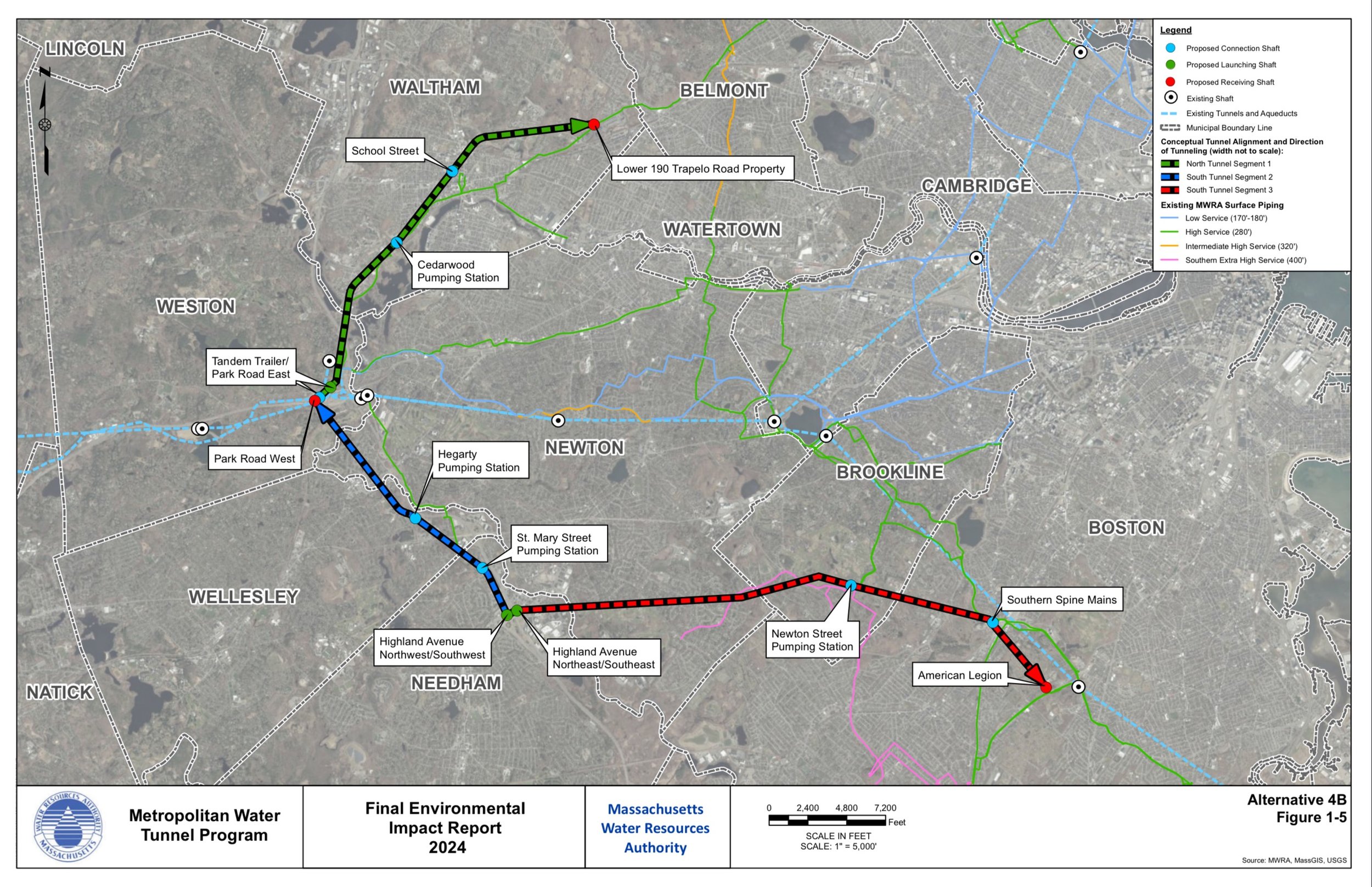
In previous public discussions, I’ve heard claims made that this water tunnel extension was continuing north into Belmont or Lexington. As a result, questions were raised about why the excavation site couldn’t be located elsewhere. However, according to the report, Waltham would in fact be the northern most termination point of the tunnel in all of the proposed alternatives even though (presumably via existing water mains) some small portion of Belmont might benefit (along with substantial portions of Waltham) from the improved water reliability.
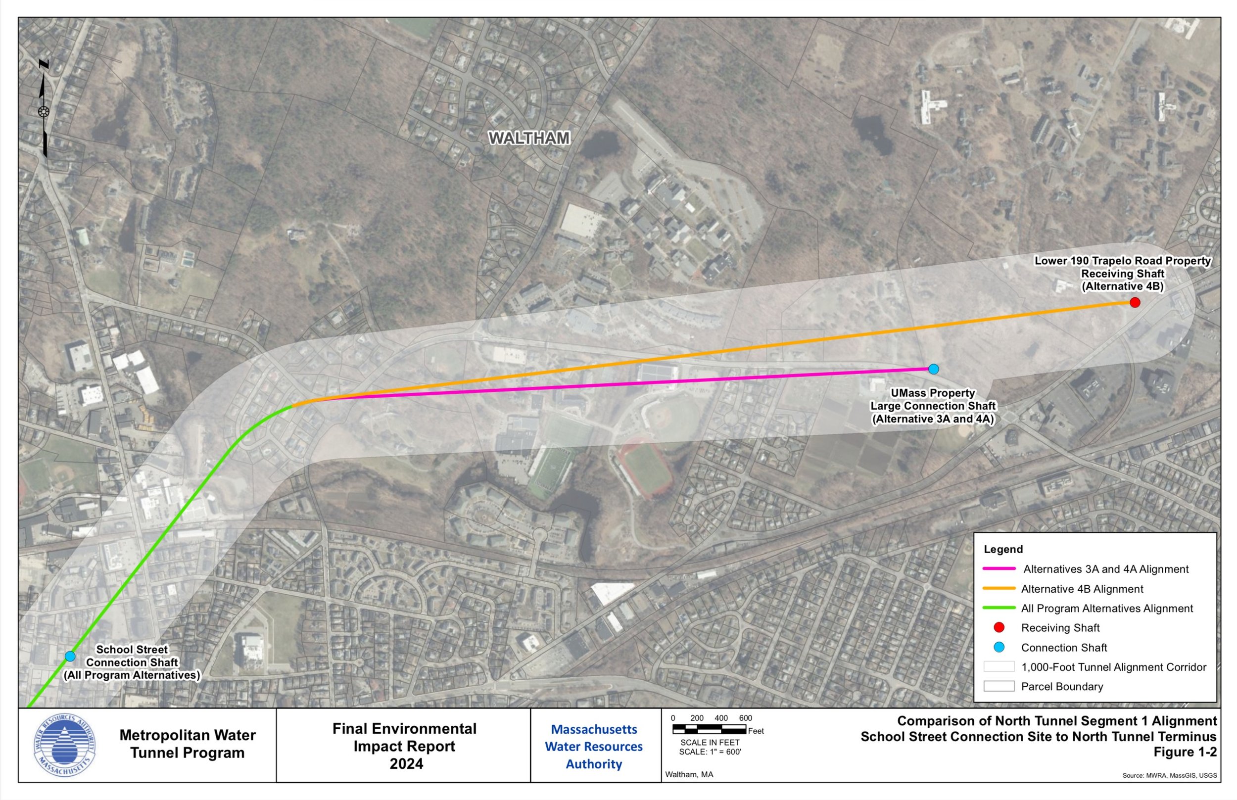
In the report, two locations appear to have been considered: the Fernald along Waverley Oaks Rd and the old U Mass property along Beaver St (adjacent to the Girl Scout camp and immediately across from the Cornelia Warren Field park and the Waltham Fields Community Farm). Of these 2 potential locations, I have to say that I would agree that the option along Waverley Oaks Rd would be far less disruptive to city residents.
Timeline of the Proposal
The MWRA has three items scheduled for 2024:
Begin final design
Conduct additional geotechnical investigations and survey
Continue extensive public engagement
For item 1, I’ll trust that the final designs are primarily technical in nature, and much the report itself describes technical and social considerations. While I’ve personally seen (and taken pictures of) item 2, I have not observed public engagement that I would consider “extensive” unless that is referring to discussions with city government officials.
Beyond 2024, it does appear that the tunneling and excavation would start in 2027 or 2028 and continue all the way until 2040! However, it is not clear the sequence of the excavation, which is divided into 3 segments (and only Segment 1 relates to the North Tunnel extension to Waltham).
Concerns about Tom Stanley’s Involvement with MWRA Proposal
A key part of the MWRA’s proposed project includes the disposition of city-owned land in a conservation area, which according to EEA Article 97 requires both 2/3rds approval by the state legislature and 2/3rds approval by the city council, which creates a scenario where the incumbent is in a position to doubly approve (or doubly oppose) the project to proceed — undermining the separation of powers that is the foundation of the American system of government. As such, Tom Stanley will need to choose to “double dip” legislatively or doubly recuse himself from the votes in both legislative bodies (abdicating his duties to the residents of Waltham in both offices).
Sean’s Position on the MWRA Proposal
While today I only have the same voice in the process as any other citizen, I would — if elected as Waltham State Rep — look to balance the obvious benefits of extending the water supply (increasing water access reliability in Waltham) with the negative externalities that would certainly accompany a protracted excavation project. In earnest, I believe that if done correctly the MWRA proposal should be a net benefit to Waltham. I propose the following mitigation measures be a condition of approving the MWRA proposal:
Construction Impact Mitigation
A dedicated website with an MWRA-staffed contact form where Waltham residents can submit question, concerns, or pictures of issues related to the construction process and receive a response within 1 business day
Online and public display of (and public comment sessions) on the maps that clarify the route any dump trucks will follow (to/from the city limits) as they enter and exit the property
Annual public comment meetings for the duration of the construction process where feedback is received and then responded to in writing or in practice within 1 week
Bond or escrow payment by the MWRA to the City of Waltham to guarantee an annual, full resurfacing of all roadways and intersections that will be utilized by dump trucks along the route
Limiting the schedule that any noise or vibrations caused by excavation can occur to 9AM - 4PM on non-holiday weekdays to avoid disruptions to sleep patterns of Waltham residents
Limiting the dump truck travel times to and from the site to 9:30AM - 3:30PM on non-holiday weekdays to minimize impacts to rush hour traffic along Beaver St, Waverley Oaks Rd, and/or Trapelo Rd
Pedestrian, Wheelchair, and Bike Accessibility & Connectivity
Construction and maintenance by the MWRA of full, safe pedestrian and bike access to the Fernald Property along the Chapel Rd entrance off Waverley Oaks Rd for the duration of the project
Prior to excavation, funding for the construction and maintenance of a pedestrian crosswalk with flashing yellow lights across Waverley Oaks Rd at the intersection of the Chapel Rd entrance to the Fernald Property
Prior to excavation, funding for the completion of the Linden St bridge renovation over Waverley Oaks Rd enabling the completion and commissioning of the otherwise built-path
Prior to excavation, funding for the construction of an ADA compliant walkway across the railroad tracks on Beaver St that does not require pedestrians reaching the end of the newly constructed path to enter lanes of traffic in order to cross the tracks
Prior to excavation, funding for the construction and maintenance of a pedestrian crosswalk with flashing yellow lights across Beaver St on the northwestern side of the Beaver Brook to the parking lot office park where the Social Security Administration building is located
After tunnel excavation and pumping station are complete, construction and maintenance by the MWRA in perpetuity of benches and a single-occupancy restroom facility with water fountain and water bottle refill station that are protected from the elements — all of which should be freely accessible to anyone 24/7/365
Since I understand that decisions on this project are likely to be made even before I could potentially take office, I invite anyone in city government or the state legislature (even my incumbent opponent) to borrow the ideas above in order to do what is best for Waltham residents!
List of Online Resources about Fernald
I’m sharing these resources in good faith for those that wish to do their own research. I’m not saying that I specifically endorse (or oppose) or have any special ability to fact check any claims or information contained on these websites.
In no particular order:
City website search results for Fernald: https://www.city.waltham.ma.us/advanced-search?keywords=Fernald
Waltham Politics Fernald Redevelopment webpage: https://www.walthampolitics.com/fernald.html
Fernald Recordation Project website: https://fernaldstateschool.com/
Ward 3 Councilor Bill Hanley’s website: https://www.190trapelo.com/
Fernald Working Group website: https://fernaldworkinggroup.org/
Video of Citizens Input Hearing: https://videoplayer.telvue.com/player/DczpPLv0_DQxyzqdZyE1r1a19QZz7VoL/media/864525
Boston Globe article about State Police Documents: https://www.bostonglobe.com/2024/04/10/metro/fernald-developmental-center-waltham-documents-records-state-police/
Note: There are many Boston Globe articles about the Fernald property, and at this point it is almost becoming a monthly segment.